


054-Coverdell Voting District, St. Charles County, Missouri
About
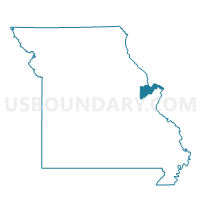
Outline

Summary
| Unique Area Identifier | 609660 |
| Name | 054-Coverdell Voting District |
| County | St. Charles County |
| State | Missouri |
| Area (square miles) | 0.85 |
| Land Area (square miles) | 0.85 |
| Water Area (square miles) | 0.00 |
| % of Land Area | 100.00 |
| % of Water Area | 0.00 |
| Latitude of the Internal Point | 38.81042990 |
| Longtitude of the Internal Point | -90.49015230 |
Maps


Graphs
Select a template below for downloading or customizing gragh for 054-Coverdell Voting District, St. Charles County, Missouri


Neighbors
Neighoring Voting District (by Name) Neighboring Voting District on the Map
- 001-Kampville Voting District, St. Charles County, MO
- 041-Government Voting District, St. Charles County, MO
- 043-Marina Voting District, St. Charles County, MO
- 045-Mamelle Voting District, St. Charles County, MO
- 051-St. Cletus Voting District, St. Charles County, MO
- 056-Edgewood Voting District, St. Charles County, MO
Top 10 Neighboring County Subdivision (by Population) Neighboring County Subdivision on the Map
Top 10 Neighboring Place (by Population) Neighboring Place on the Map
Top 10 Neighboring Unified School District (by Population) Neighboring Unified School District on the Map
Top 10 Neighboring State Legislative District Lower Chamber (by Population) Neighboring State Legislative District Lower Chamber on the Map
Top 10 Neighboring State Legislative District Upper Chamber (by Population) Neighboring State Legislative District Upper Chamber on the Map
Top 10 Neighboring 111th Congressional District (by Population) Neighboring 111th Congressional District on the Map
Top 10 Neighboring Census Tract (by Population) Neighboring Census Tract on the Map
- Census Tract 3103.01, St. Charles County, MO (4,142)
- Census Tract 3102.02, St. Charles County, MO (3,747)
- Census Tract 3103.02, St. Charles County, MO (3,666)
- Census Tract 3102.01, St. Charles County, MO (2,679)
- Census Tract 3104, St. Charles County, MO (2,117)
- Census Tract 3115, St. Charles County, MO (1,905)